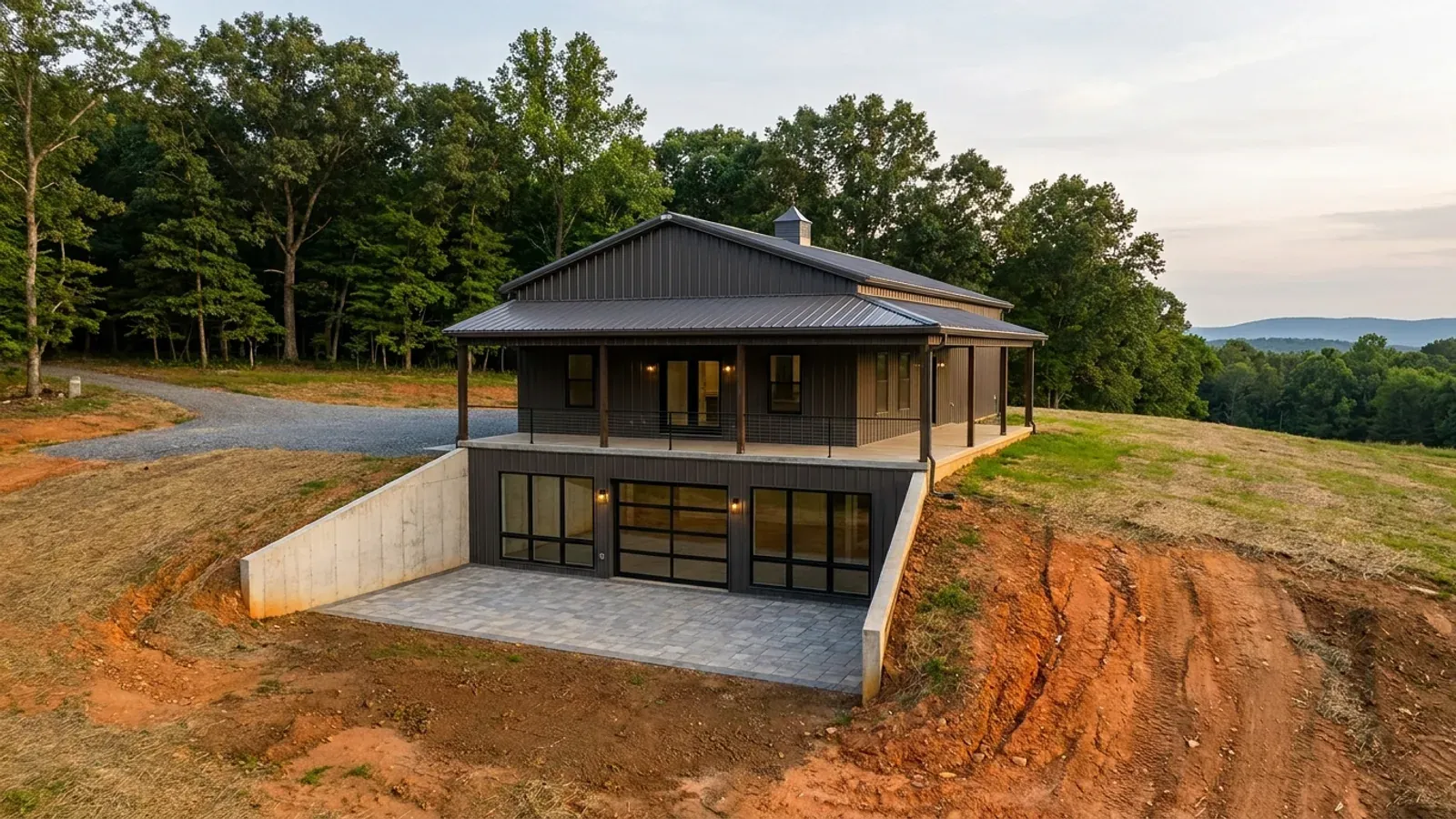
Barndominium with a Basement in Virginia
A basement is the one part of a barndominium that is decided by the ground rather than by the plan. The mechanism is easier to see once you know how soil surveys rate it: the national soil survey scores "dwellings with basements" as a separate interpretation from "dwellings without basements", because the two assume different excavations — spread footings on undisturbed soil at about two feet, or maximum frost penetration if that is deeper, for the building with no basement, and about seven feet for the one with. Every limitation that lives between those two depths shows up in one rating and is invisible in the other. That is why a parcel can be perfectly good ground for a slab-on-grade barndominium and impossible ground for the same building with a basement under it, and why the answer changes over a few hundred feet rather than over a county line. This page is about which limitation you are likely to be meeting, where, and where the ground is genuinely deep enough that a walkout is the obvious move.
What actually changes with this feature
The look is the easy part. These are the decisions that follow from it.
Piedmont and Blue Ridge — the excavation hits rock
The soils that dominate the Virginia Piedmont are residual, weathered in place from granite, gneiss and metamorphosed volcanics, and their depth to a restrictive layer varies enormously across short distances. In the Lynchburg and Campbell County survey area, Manteo has lithic bedrock at 38 centimetres and Wilkes at 74; Tatum carries paralithic bedrock at 127 centimetres. The steepest ground is where the shallowest soils are — Manteo's largest map units run 25 to 60 percent slope — and about 27 percent of that survey area's mapped soils sit in map units reaching 25 percent slope or steeper. Further west the same problem is measured county-wide: bedrock within one metre on 125,034 acres of Floyd and 96,293 acres of Pulaski. A seven-foot excavation into that is rock work, not soil work, and the cost of it is set by how much rock rather than by the size of the basement.
Coastal Plain — the excavation fills with water
East of the fall line the constraint reverses. New Kent County's soil data gives the shape of it plainly: of 141,380 mapped acres, 46,982 rate well drained and 35,437 moderately well drained, but 24,568 acres — better than one in five of the classified total — rate somewhat poorly to very poorly drained, and the county's dominant limiting feature for a septic absorption field, at 75,732 acres, is groundwater near the surface. Component by component the seasonal high water table sits at 15 centimetres in Roanoke, Tomotley and Nimmo soils, 31 in Wahee, 46 in Augusta, 61 in Altavista, Tetotum and Munden, and 69 in Nevarc, Slagle and Dogue — and Nevarc alone is 21,180 weighted acres. In Isle of Wight the equivalent figure is 68,320 acres, roughly a third of the mapped land, poorly or very poorly drained with the water table within about a foot of the surface. A basement floor at seven feet is below all of those, so the question is not whether water reaches it but what the drainage and the hydrostatic design have to do about it.
The I-81 corridor — voids, and almost no regulation of them
Virginia Energy states that most of the state's karst region follows Interstate 81 and that twenty-seven Virginia counties lie in that zone, and records the March 2001 closure of a nine-mile stretch of I-81 in Augusta County after three sinkholes appeared, the largest 20 by 11 feet and 22 feet deep, and the October 2004 collapse of a southbound lane in Montgomery County. A 2003 Virginia Tech study puts the share of county area in karst at 60 percent for Lee; 50 percent for Giles, Highland, Russell, Scott, Shenandoah and Washington; 40 percent for Augusta, Bath, Montgomery, Pulaski, Rockbridge, Rockingham and Tazewell; and 30 percent for Alleghany, Clarke, Craig, Frederick, Page, Smyth, Warren and Wythe. The Department of Conservation and Recreation's own karst page states that few other legally binding mechanisms established for protection of karst features exist in Virginia — so outside a locality with its own overlay this is a matter of prudence rather than of permitting. Geography does not predict it: Loudoun's karst is east of the Blue Ridge, in the Culpeper Basin. Where an assessment is called for, the state's Karst Assessment Standard Practice asks for a geologist with a minimum of five years of experience in karst geology or hydrology, or a Certified Professional Geologist.
Where a walkout genuinely works — deep saprolite with fall
The combination a walkout basement wants is slope for the daylight wall and depth for the excavation, and the Virginia Piedmont supplies it wherever the soil is one of the deep residual series rather than a shallow one. In the Lynchburg and Campbell survey area, Cecil, Cullen and Appling — between them the largest mapped soils there, running to tens of thousands of acres on 2 to 15 percent slopes and all rated well drained — carry no restrictive layer at all in the queried depth. That is the ground: deep, well drained, gently to moderately sloping. The same duality shows up in the mountains, where the counties that are half shallow rock are also, on the other half, deep: 110,372 acres of Floyd and 72,732 acres of Pulaski have no bedrock within 200 centimetres. Even on the Coastal Plain there are dry-footed soils — in New Kent, Remlik at 18,533 weighted acres and State and Bojac all hold the seasonal high water table at 153 centimetres, about 60 inches, and Emporia at 10,009 acres holds it at 114. The honest conclusion is that a basement in Virginia is a parcel question, not a county question, and it is answered by soil borings on the site.
Rock in the west, water in the east, voids down the Valley
In the Piedmont and Blue Ridge the limit is depth to rock. In the survey area covering Lynchburg and Campbell County the Manteo series carries lithic bedrock at 38 centimetres — about fifteen inches — on map units running 25 to 60 percent slope, and Wilkes carries it at 74 centimetres on 15 to 60 percent slopes; together those map units run to tens of thousands of acres. Further south-west, bedrock sits within one metre of the surface on 125,034 acres of Floyd County, 51.2 percent of it, and on 96,293 acres of Pulaski County, 51.1 percent — the two counties agree almost exactly on the number and differ completely on the reason, shallow crystalline rock in Floyd against pinnacled carbonate in Pulaski, where the depth to rock is unpredictable over a few feet. On the Coastal Plain the limit is water. In New Kent County the top limiting feature for absorption fields, across 75,732 of the county's 141,380 mapped acres, is groundwater near the surface — not clay and not slope — and Nevarc, the single largest soil in the county at 21,180 weighted acres, holds water within about 27 inches of the surface at its wettest. In Isle of Wight, 68,320 acres, about a third of the mapped land, is poorly or very poorly drained with the seasonal high water table within a foot of the surface. And down the Interstate 81 corridor the limit is carbonate: Virginia Energy states that most of Virginia's karst region follows I-81 and that twenty-seven of Virginia's counties lie in that zone.
Common ways to build this
Common configurations we see. Yours does not have to match one exactly — this is a starting point for the conversation, not a catalog.
Full walkout on a side-hill
2,400 sq ft main level over 2,400 sq ft basement, one wall at grade
The version that earns its money. Cutting into a slope of roughly 8 to 15 percent gives a full-height daylight wall on the downhill side with windows and a door, so the lower level is habitable space rather than storage, and the excavation is a cut into the hillside rather than a hole. It suits the deep, well drained Piedmont soils — Cecil, Cullen and Appling ground — where there is no restrictive layer in the excavation depth. Check the locality's slope threshold before committing to the grade: Virginia publishes no single figure, and the localities that do publish one differ, with Albemarle and Lynchburg at 25 percent, Frederick at 35, and Isle of Wight at 15 and 30. Roanoke County's Office of Building Safety publishes that the code it enforces regulates slopes above 33.3 percent, requiring an engineered site study and foundation plan before permit.
Daylight basement under the living end only
1,200 sq ft basement under the house / slab under the shop
Putting the basement under half the run and pouring the shop bay on grade halves the excavation, keeps the shop floor at driveway level where a vehicle can be driven straight in, and puts the daylight wall on the end of the building with the view. It is the practical form on ground with modest fall, and the one that keeps the deep excavation away from the part of the site that has to take vehicle loading. It also keeps the two slabs at different levels, which matters for the under-slab vapour retarder: R506.2.3 requires a minimum ten-mil retarder under the conditioned part and excepts garages, utility buildings and other unheated accessory structures.
Storm and mechanical basement — partial, no daylight
roughly 400 to 600 sq ft under the utility core
A partial basement holding the mechanical plant, the water treatment and a shelter, reached by interior stairs, with the rest of the building on slab. It is the version that survives a site where the good ground runs out — a limited excavation can often be placed on the deepest part of the parcel where a full one cannot. It is also the version to reach for where a fee schedule charges by gross area including the basement, since several Virginia localities do: Prince William charges per square foot of gross floor area to include basements and garages, Rockingham charges on gross finished floor area including basement area, Culpeper's dwelling permit and plan review rates both apply to gross building area including basements and conditioned crawl spaces, and Spotsylvania's Gross Building Area includes the basement.
Conditioned crawl space instead
no excavation below footing depth
Where the borings come back with rock or water in the first metre, the sealed conditioned crawl space is the alternative that gets most of the practical benefit — serviceable mechanical runs, a dry floor assembly, no slab penetrations — without the seven-foot dig. Virginia amended the code to require dehumidification sized at 70 pints per day per 1,000 square feet of crawl space floor area in an unvented crawl space, which is a specific and quotable Virginia number, and added a termite inspection gap requirement. On the Coastal Plain in particular this is usually the right answer rather than a compromise: in New Kent the largest soil in the county holds water within about 27 inches at its wettest, and in Isle of Wight about a third of the mapped land is poorly or very poorly drained with the water table within a foot of the surface.
Ways to build this size
A footprint can go together several ways. These are the service lines most relevant to it.
Site Preparation
Clearing, grading, pad, drainage and utilities, plus the septic work that has to clear before any building permit can issue.
Read moreCustom Plans
Barndominium floor plans drawn to your parcel and to the design criteria your own Virginia locality publishes, not to a generic national spec.
Read moreTurnkey Builds
Start to finish barndominium construction: permits, site work, shell and full interior finish, under one contract and one schedule.
Read morePost-Frame Homes
Post-frame construction built as a dwelling under the Virginia code, with wide clear spans and a straight answer on the farm-building exemption.
Read moreBarndominium with a Basement: common questions
7 questions we get asked most often about this footprint. If yours is not on the list, ask it directly.
Why are basements less common in Virginia than you would expect?
Where in Virginia does a walkout basement actually work well?
Is there a rule against basements anywhere in Virginia?
What does a basement have to be insulated to?
Will a basement change what the county asks for on the plans?
Does the basement count toward permit fees or accessory-structure caps?
Should karst stop me building a basement in the Valley?
Want this drawn for your program and your parcel? That is where a build actually starts.
Start your plans
Tell us what you want to build and we will draw this for your program, then confirm what it looks like on your parcel, the wind load it has to meet, and a realistic budget range. That conversation costs nothing.